
On this page: Ruby E · El Rey · NOSC Tower · Ingraham St. Bridge · HMCS Yukon · Mission Bay Channel
All Wreck Alley dives are boat dives, either through one of several local dive boat operators or using your own or your friend’s boat. If you have updates to these descriptions to add, please get in touch. Thank you!
<!–
The following information is from Woody Morrison, SDOF Wreck Alley Mooring Project Chairman [August 2004]
The SDOF Wreck Alley Mooring Project’s goal is to keep the wrecks in SD moored for easy access, and to create a safer boating environment in the vicinity of the popular dive areas. These moorings are for the general public, all are welcome to use them.
The Yellow Can Marker on the Yukon and White Can Marker on the Ruby E
These are not moorings, please do not use them as such. The markers are there for easy identification for dive boaters and for easy avoidance by other boaters. The Yukon yellow marker in particular is very expensive, very heavy and has a radar reflector inside to help larger boats en route back to the harbor at night avoid the area. Using this as a mooring weakens the system unnecessarily. Please encourage others boaters you see not to use these markers. When that marker breaks free, it is a major endeavor to replace it.
Moorings
Each mooring ball has a "painter" or a line coming off the mooring to use. Please put your own line through the loop at the end; do not bring the painter onto your boat. We use polypropylene line for the painters which is extremely durable in all instances except one; it chafes badly when rubbed against the edge of a boat under pressure. Friction is the killer for this type of line. There are lines that are stronger, and much more expensive, but do not float. A 10′ to 15′ section of line is ideal; tie one end to your boat, thread through the loop and tie the other end back to your boat creating a "bridle". It is perfectly acceptable to tie your line directly to the loop, but this is much harder to undo when there is wind and swell.
Sharing Moorings
Moorings are first come first served, but small boats should share whenever possible. 2–3 inflatable or comparable sized hard boats are fine on a mooring. Larger boats (25’+) under most conditions should not share moorings; this creates more strain on the lines than is needed. Larger boat operators should be proficient enough at anchoring, that a mooring should not be a major issue. Commercial dive boats have been the major source of funding for this project, if you want to show them your appreciation, let them have a mooring when it’s possible. Commercial boat operators may not want you to tie to them; they have the safety and comfort of a large group of divers to consider. Do not assume it is ok to share a mooring with a commercial operator, ask first.
Wear and Tear
This stuff wears out; the ocean is a brutal place. If you notice chain links wearing thin or a line you think may break, please send me an email at the address below. All of us on this project are volunteers, so our time spent on the moorings is usually delegated to repairs. Any additional info we can get from regular divers is fantastic and helpful. The SD Lifeguards have been exceptional in helping us recover moorings that have come free, as well as allowing us to store large items on their moorings in the harbor during the winter months.
Winter
We often do not replace moorings in the winter; no sense in putting out expensive gear only to subject it to our winter swells and storms. Anything that breaks free during the winter is replaced in late March.
Expenses
There are three sources of income for the moorings project: regular donations from the Dive Operators, Wreck Alley T-shirt Sales, and individual donations. All project members are volunteers and the use of the Lois Ann has been donated by her owners for this project. I do not own the Lois Ann.
Our project is unique, I don’t know of another like it. Help us keep the moorings in place and usable by following the few simple tips listed above!
If you have any questions, feel free to email me directly.
Woody Morrison [email Woody]
SDOF Wreck Alley Mooring Project Chairman
–>
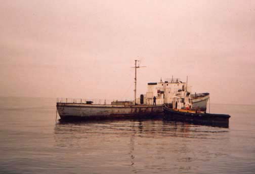
The 165 foot salvage vessel Ruby E, formerly a Coast Guard cutter, was intentionally sunk in Wreck Alley on June 18, 1989, to join the El Rey as a dive attraction.
Come out of the Mission Bay Channel and take a heading of 290 degrees for 1 mile. Look for the yellow spar buoy marking the stern of the Ruby E. This is not a mooring buoy! The spar buoy is moored just a bit south of the stern of the wreck. The small white buoy north of the spar buoy is attached to the bow of the Ruby E. The Ruby E sits in about 85 feet of water, with her deck at about 65 feet. GPS coordinates are N 32 46.008, W 117 16.569.
California Wreck Divers page on the Ruby E
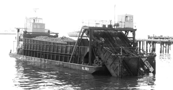
This 100 foot kelp harvester was sunk April 2, 1987, as a dive attraction.
Come out of the Mission Bay Channel and take a heading of 285 degrees for a little under a mile. The El Rey is about one-quarter mile south of the Ruby E. She also has a yellow spar buoy (not a mooring buoy!), which is attached to the El Rey amidships. The El Rey also sits in about 85 feet of water, with the deck at about 75 feet. She’s a very shallow wreck, that consists primarily of a barge with mostly collapsed superstructure on her stern end. GPS coordinates are N 32 45.825, W 117 16.622
California Wreck Divers page on the El Rey
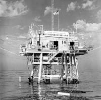
The NOSC (or NEL) Tower was built in 1959 and lasted until the El Nino storm in January 1988. Her labs stuck some 50 feet out above the water until the morning after the big storm, when she was simply gone. When standing, her footprint was approximately 40 ft. by 40 ft., and she was a bit over 100 ft. tall. She did not fall straight when she went down, she twisted. Parts of the labs at the top were broken off by the storm and never found. The Tower at times has a marker buoy, and at times does not. The tower coordinates are N 32 46.360, W 117 16.113. The Tower sits in about 55 feet of water and has 20–25 feet of relief.
Here are line-ups for the Tower: Sea World Tower on the third arch from the right on the Belmont Park facade; end of Crystal Pier pretty much on the right edge of the tall hotel (condos?) behind the pier (the left of the two taller buildings in P.B. behind the pier).
A little background from Brian Williams about the Tower (remembering, of course, that much of the above-water section of the Tower is NOT a part of the now submerged wreck): “The NOSC tower actually had four levels: there was a ‘surface’ or ‘entry’ level deck and diving platform (the lowest and smallest level); the level above that contained winches and other devices which were used for lifting equipment. The next floor up was the primary work area: this was a well-sheltered area with an electronics room, a general purpose room, and a bunk room that slept about a half-dozen or so. The fourth level was the top level and had antennae for wind-recording or solar measurement instruments.
The Tower was used for all kinds of programs involving the study of internal waves, surface water temp, swell and wind waves, acoustic studies, electromagnetic / wave propagation studies, biological studies, etc.”
NOSC Tower information BEFORE sinking
NOSC Tower photos AFTER sinking
In 1992, the California Department of Fish & Game’s Artificial Reef Program put down a bunch of rubble from the old Ingraham Street Bridge as an artificial reef in Wreck Alley. The DFG lists the coordinates at 32° 45′ 51″ N and 117° 16′ 31″ to who’s dived the Ingraham Street Bridge Swears that it’s in 60′ of water. The DFG coordinates (on the map below) have it close to the El Rey, which should put it at 80 fsw or so. Can anybody clear this up?
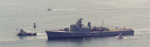
For several years the San Diego Oceans Foundation, in a project run by Dick Long of DUI, worked hard preparing to bring the Canadian warship HMCS Yukon down to San Diego to be sunk as an artificial reef in Wreck Alley. Once the Yukon arrived in San Diego, many volunteers spent countless hours cleaning and preparing the ship for sinking. Finally, everything was in place for the Yukon to be sunk on Saturday, July 15, 2000, amidst much fanfare. She was towed out to her sinking site on July 13th, after which she began taking on more water than the one pump on board could handle. Some of the pre-cut outer hull holes were too close to the waterline for the swell that was coming in that evening. Shortly after midnight, the Yukon sunk—on her own terms. Instead of landing upright, she landed on her port side.
Because the Yukon sank herself and is now on her port side, she is a much more challenging wreck than intended. None of the entry/exit holes below the waterline were blown out, so many of the planned holes simply do not exist. Also, some of the port side holes are now buried in the sand. Some people find the sideways wreck disorienting, some do not. PLEASE DIVE THE YUKON WITHIN THE LIMITS OF YOUR EXPERIENCE.
The Yukon sits slightly northwest of the other wrecks in Wreck Alley in 100′ of water. The top of the wreck (starboard rail) is at about 55′. There are many buoys over the Yukon, although it’s not uncommon for them all to be taken, both by commercial and private dive boats. Her coordinates are 32 46.814, 117 16.936.
Yukon BEFORE sinking
The Yukon first arriving in San Diego
A tour of the Yukon in September, 1999, during preparation for sinking
A tour of the Yukon in February, 2000, during preparation for sinking
Yukon SINKING
Video of the Yukon accidentally sinking in the middle of the night
Yukon not long AFTER sinking
Photos from Summer 2000, right after the Yukon sank
Yukon longer AFTER sinking
NOTE: To avoid diving in the polluted waters of Mission Bay, do this dive on an INCOMING tide.
[This dive site description is courtesy of John Capoot.]
This has been one of my favorite spots for years. It’s easy (once you get in the water), you get lots of bottom time (as much as 1 1/2 hours on an aluminum 80) because it’s generally less than 20′ deep, and there are tons of things to look at.
To dive the North Jetty, go south to the end of Mission Boulevard and turn either left to the bayside parking lot or right to the ocean side parking lot. The entrance is a little easier on the bay side since you don’t have to climb up the rocks and back down again.
To dive the South Jetty, take Quivera Road around to the end, near the Lifeguard HQ, and enter the water there—directly on the south jetty.
Depending on your ability to negotiate the large boulders, you may choose to carry your stuff down the the water a little at a time. The trip back up is much easier than you would think and can usually be accomplished without taking off any gear (except your fins). We always plan a dive about two hours before high tide. That gives you the cleanest possible water and makes it easier to drift back to your exit spot at the end of your dive. Once you get in the water, stay as close to the rocks as possible to avoid becoming a navigation hazard. Drop down along the boulders until you hit bottom. Your dive will be along the rock jetty from the sand line up the rocks. The trick here is to stay within a few feet of the rock/sand line since that’s where all the action is. Head out, against the incoming tide and when your dive is finished, simply surface and drift back to where you started. when you surface, follow the slope of the rocks up and you will come up well away from any boat traffic. Even the kayakers don’t get that close.
We night dive for lobsters and see lots of sea urchins, octopus, starfish, sandollar beds, rock scallops, wavy top shells and chestnut cowries.
Check it out for a change of scenery, or on a day when it’s crummy everywhere else. The channel is protected from the most of the surf so even with lousy vis, you can still have an interesting dive in the channel and not loose your buddy.